
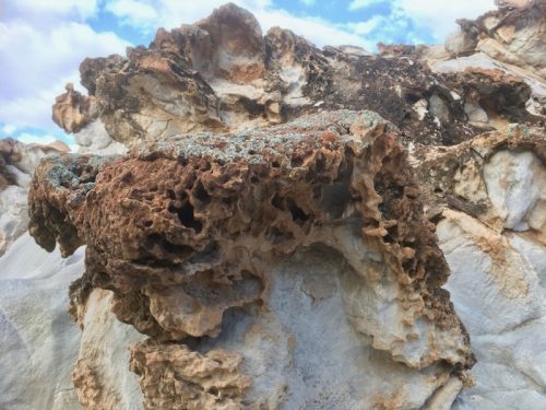
Iron hydroxides percolating through sandstone can form concentric patterns called Liesegang rings. These palm sized samples were seen in a localised area to the west of Leigh Creek in the Flinders Ranges.


Iron hydroxides percolating through sandstone can form concentric patterns called Liesegang rings. These palm sized samples were seen in a localised area to the west of Leigh Creek in the Flinders Ranges.

The Akurra trail is a 10.5km (4hr) walk from Leigh Creek township to the picturesque Aroona Dam. Commencing at the health clinic, the path is clearly signposted and includes cultural information. It traverses the magnesite rich Myrtle Springs Formation, the colourful ridge of the Skillogalee Formation, and into the towering dam walls of the Copley Quartzite Formation.

Trail map can be downloaded, and you can also pick up an informative brochure at the Leigh Creek supermarket. On your way back, you can drop into the Leigh Creek Library geological display of local rock and mineral samples.

Moro Gorge is a cascading series of spring-fed waterholes located in the Nantawarrina Indigenous Protected Area in the northern Flinders Ranges. The surrounding limestone walls appear to have precipitated from mineral-rich spring water, forming tufa columns and flowstone. Calcrete is also present in the area—a type of limestone conglomerate consisting of pebbles bound within a calcium carbonate matrix.


Muddy limestone turbidite, formed from sediment deposits in offshore silty waters during the Cambrian period (around 550 million years ago). The dramatic localised buckling seen here may have occurred in situ during a turbulent underwater event. This rock is part of the Mernmerna Formation in the northern Flinders Ranges.


Laminar manganese-rich limestone of the Nepabunna Formation, formed during the Cambrian period, is now exposed and weathering on the plains north of the Flinders Ranges.


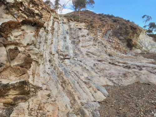
This striking outcrop near Copley exhibits a range of sedimentary deposits. From the north to south, green shale and blocky siltstone meets weathered sandstone. This is followed by a distinct tillite layer between two dolomite layers, and a thin layer of quartzite. Further along, siltstone layers coloured by iron oxide, and more weathered sandstone.
Recent studies in the area suggest that the northern Flinders Ranges area was a shallow marine or lagoonal setting prior to the climate changing into one of the earth’s most severe glaciations ever recorded (the global Sturtian Glaciation), 720 million years ago . Over these older rocks, we find layers of pebbly, mixed rocks (called diamictites) that were likely deposited by a glacier at its edge, along with some sand layers (Bolla Bollana Tillite). These rock layers are thought to show the movement of the glacier as it advanced and retreated along the coastline. These layers then change into sandstones and mudstones with large rocks (called dropstones), which probably formed when the ice started to melt, in an area just in front of the retreating glacier (Wilyerpa Formation). After the glacier melted, the layers of rock that formed (Tapley Hill Formation) include thin, layered shales and carbonates that were deposited underwater.
Weathered sandstone:
 Continue reading “Glacial geological formation: sedimentary deposits”
This gully parallel to Glass Gorge Rd near Blinman delineates two chapters of sedimentary deposition in the formation of the Flinders Ranges – the Bunyeroo Formation purple shale (right), and white-weathering calcareous Wonoka Formation (left).
An amazing overview of the formation of the Flinders Ranges can be found in our feature essay, Legacy of Time, by the Royal Geographical Society of South Australia.

These flute casts are part of the limey mud deposits of the Wonoka Formation. Flowing water in the marine trough (the Adelaide Geosyncline approximately 580 mya) hollowed grooves (flutes) into deep sea floor sediments. These flutes fulled with slurries of mud which are preserved as flute casts seen in Bunyeroo Creek in the Ikara- Flinders Ranges National Park.


Example of barite sand nodules in a Rawnsley Quartzite boulder formed in shallow water below the surface of the sand, with quartz grains cemented by barium sulphate later replaced by fine grained quartz to form lumps.


The Bonney Sandstone Formation is the result of deposition of iron-stained sand, silt and mica, eroded from older igneous rocks to the west and transported by rivers into a large delta. This formation has a distinctive reddish colour, and is often seen alongside the harder weathering prominent peaks of Rawnsley Quartzite which was formed from white sands, 600 million years ago. See the essay Legacy of Time by The Royal Geographical Society of South Australia for the riveting story of the formation of the Flinders Ranges.

