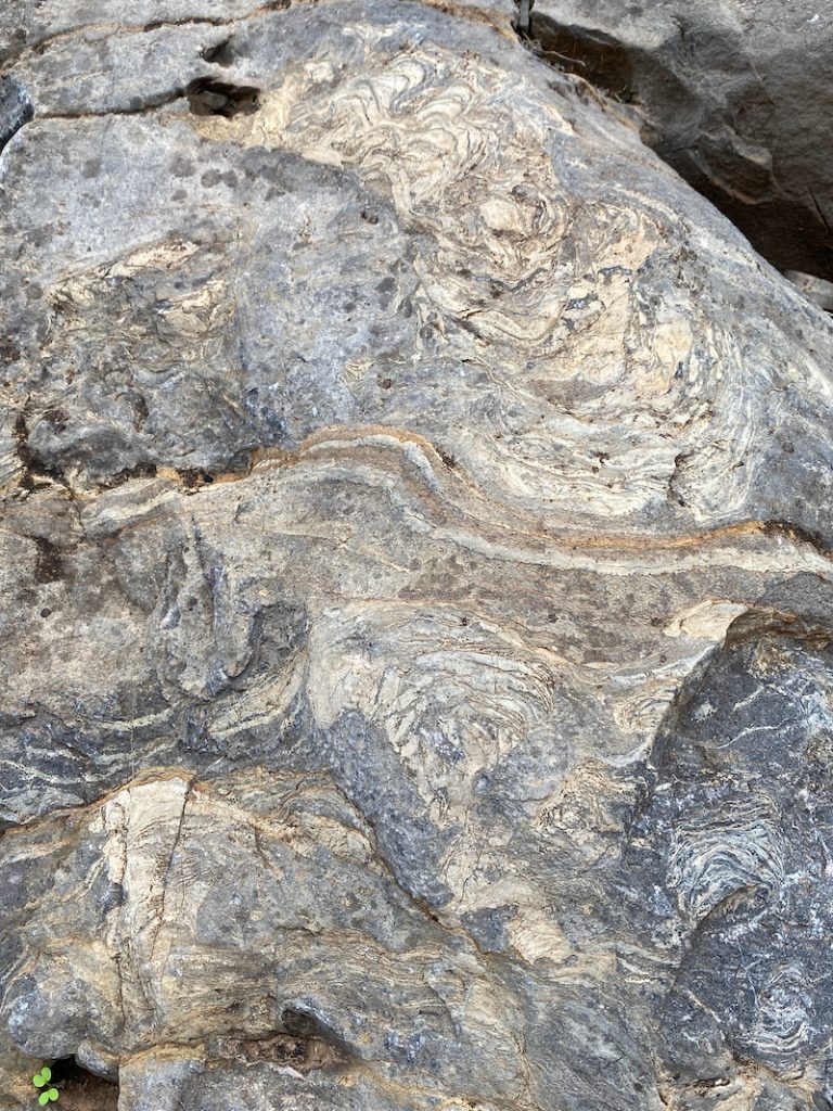
Stromatolites are fossilised biochemical accretionary structures created by Cyanobacteria (‘blue-green algae’) colonies which form microbial mats and laminated mounds in shallow saline waters. These specimens of early life were trapped and preserved in the limey mud of the Wonoka Formation laid down in the marine trough of the Adelaide Geosyncline 570-580 million years ago.
This outcrop of nodular limestone can be seen 4km into Bunyeroo Creek from the road. Part of the Wilkawillina Limestone Formation (dating 530 million years ago), the origins of this lumpy limestone remain a mystery.
Arkaroola Education and Research Foundation with the Geological Survey of South Australia have published an excellent series of Geological Field Excursion Guides. Volume 1 is a self-guided driving tour from Arkaroola Village to Paralana Hot Springs, and Volume 2 is from Arkaroola Village to Sillers Lookout. The guides contain localised geological maps, satellite images and site photographs, with clear instructions on how to find specific formations en route. The accompanying geological notes are highly informative and a wonderful way to discover the stunning geological diversity of Arkaroola.
Australian Geology Travel Maps by Trilobite Solutions is a simple and effective mobile app that operates offline. In addition to terrain and satellite maps, it offers a selection of interactive maps of Australia and NZ for a flat rate of $11.99 per year. These include detailed and simple geological maps by state. This is a wonderful way to locate your position on the geological map and to instantly display geological information about your immediate location. The app also has a voice function that informs you about the geology whenever there is a change, which is great for road trips.
Mineral, exploration and mining data layers can also be downloaded, and various layers can be overlaid. Locations and trails can be recorded and exported in various GPS formats.
As the internet in the Flinders can be patchy and weak, it is advised that all maps and layers be downloaded in advance. The simple geological map for SA was around 1gb and the detailed geological map for SA was around 1.4gb.
This app could very well be an improvement on using a magnifying glass to read a geological map flapping in the wind on a hot car bonnet.
This 80m long creek bank in Parachilna Gorge exposes colourful sedimentary laminae (1-25mm wide) of the Bunyeroo Formation.
As outlined in The Legacy of Time: The Story of the Flinders Rangesby the Royal Geographical Society of South Australia, the layers are likely to have been formed by marine deposition of fine-grained silts following the end of an ice age (650ma). The vertical bedding exposes micro-faults and folding that occurred during the formation of the Blinman dome.
The site is easily accessed on the northern bank of the creek at the turn-off to Glass Gorge Rd from Parachilna Gorge Rd.
The Ajax Limestone in the Northern Flinders Ranges includes a significant array of Lower Cambrian Archaeocyath fossils, replaced by quartz, exposed in ground-level limestones.
Skillogalee Dolomite includes blue-grey dolomites, magnesites, bands of black cherts and stromatolites. Magnesites (magnesium carbonate) of this formation were formed in marginal lagoons of the Adelaide Geosyncline around 750 million years ago and occur as beds, commonly conglomerate in texture, as pictured below.
A geological unconformity is an unconformable contact between two different lithologies. In the case of this formation in Jubilee Creek in the Northern Flinders Ranges, stromatolitic limestone of the Balcanoona Formation overlays laminated mudstone of the Tapley Hill Formation.
These two formations followed the melting of an ice age dating 700 million years ago. “Black silt, rich in fine organic material derived from algae and bacteria, was deposited as laminations (each less that 0.5mm thick) in the calm shelf sea. The total thickness of this silt blanket (known as the Tapley Hill Formation) increased from a few tens of metres in the west to about 3km in the ranges east of Hawker. Here depth of water and rate of subsidence of the basin floor were greatest. As silt built up, the water around the margins of the basin became shallow enough for stromatolites and oolite banks to form; these are exposed near Port Augusta and Balcanoona [Balcanoona Formation].” – Excerpt from The Legacy of Time: The Story of the Flinders Rangesby the Royal Geographical Society of South Australia.
Iridescent coating is not a true mineral but a nanomineral, associated iron oxides (though not exclusively) such as this example of Turgite. The nano-crystal array of the fine iridescent coating layer diffracts and scatters beams of light, producing a rainbow effect.