
This outcrop of nodular limestone can be seen 4km into Bunyeroo Creek from the road. Part of the Wilkawillina Limestone Formation (dating 530 million years ago), the origins of this lumpy limestone remain a mystery.


This outcrop of nodular limestone can be seen 4km into Bunyeroo Creek from the road. Part of the Wilkawillina Limestone Formation (dating 530 million years ago), the origins of this lumpy limestone remain a mystery.


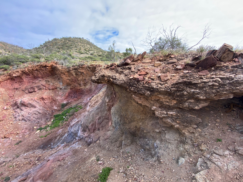
This 80m long creek bank in Parachilna Gorge exposes colourful sedimentary laminae (1-25mm wide) of the Bunyeroo Formation.
As outlined in The Legacy of Time: The Story of the Flinders Ranges by the Royal Geographical Society of South Australia, the layers are likely to have been formed by marine deposition of fine-grained silts following the end of an ice age (650ma). The vertical bedding exposes micro-faults and folding that occurred during the formation of the Blinman dome.
The site is easily accessed on the northern bank of the creek at the turn-off to Glass Gorge Rd from Parachilna Gorge Rd.

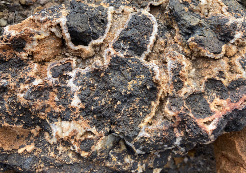
Iridescent coating is not a true mineral but a nanomineral, associated iron oxides (though not exclusively) such as this example of Turgite. The nano-crystal array of the fine iridescent coating layer diffracts and scatters beams of light, producing a rainbow effect.

Mt Neill Granite is exposed in a rocky creek near Paralana Hot Springs. The red feldspars of this 1580 million year old formation present in a variety of forms.


This lightweight Kaolinitic Granite at NE Arkaroola is an alteration of Mt Neil Granite. Hydrothermal fluids have destroyed the micas and replaced the feldspars of the original granite (1580 million years old) with Kaolinite.

For more information on how to locate this site, see Geological Field Excursion Guides.
The Wooltana Volcanics formation (830 million years ago) is visible on exiting Claude Pass on the Paralana Road at Arkaroola.
For more information on how to locate this site, see Geological Field Excursion Guides.
Ripple marks, mud cracks and rain drop imprints indicate a shallow aquatic environment when the sediments of the Wortupa Quartzite formation were deposited around 790 million years ago.


For more information on how to locate this site, see Geological Field Excursion Guides.
Download PDF:
Published by the Geological Society of Australia, South Australian Division.
Excerpt:
One of the best records in the world of sedimentary deposition in the period of geological time between about 800 million and 500 million years ago is exposed in the Flinders Ranges, Mount Lofty Ranges and the Olary region in South Australia. Sandy and silty sediments derived from erosion of older rocks of the Gawler Craton in the hinterland to the west, and island masses of this basement rock rising from an undersea ridge over 200 km to the east, were deposited into an extensive marine basin called the Adelaide Geosyncline in which the seafloor was slowly subsiding along a series of elongated north-south step or graben faults.
During the 300 million years of continuing but intermittent subsidence of the basin floor, a thick pile of sediment accumulated in the geosyncline. This sequence was then compressed and hardened by deep burial and later folded into a high mountain range by a new regime of earth movements.
Subsequent erosion has reduced these highlands to their present form and deposited huge amounts of sediment to the east into younger sedimentary basins formed by later crustal down warping. Continue reading “Brachina Gorge Geological Trail”
 An outcrop of blocks of sandstone and beds of crystalline calcite in the vicinity of a copper deposit.
 Continue reading “Sandstone and Calcite outcrop: Finniss Springs”
Silicified duricrust formed in low laying outer areas of the Flinders Ranges, likely to have once been saturated by limey waters. Surrounding sediments have eroded leaving these typically rounded, hard wearing silcretes.

